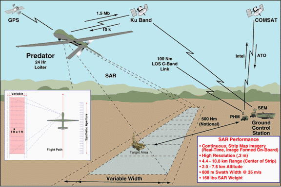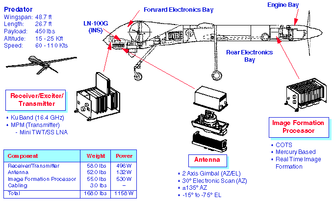


 TESAR (Tactical Endurance Synthetic Aperture Radar) (also called the MAE UAV SAR) is a strip mapping SAR providing continuous 0.3 meter (1 foot) imagery. The focused imagery is formed on-board the Predator aircraft, compressed and sent to the Predator Ground Control Station over a KU band data link. The imagery is reformed and displayed in a scrolling manner on the SAR workstation displays. As the imagery is scrolling by, the operator has the ability to select 1k by 1k image patches (approximately 800m x 800m box at 15,000 AGL) for exploitation at the Predator DEMPC workstation. The imagery is also
recorded continuously on DLT tapes.
There are 2 modes of operation. Mode 1 provides a non-centered strip map. That is the map center moves with respect to the aircraft motion. Mode 2 is the classic strip map mode. Mapping occurs over a predetermined scene center line, irrelevant ot the aircraft motion.
The radar is designed to map while squinting up to �45 degrees off the velocity vector. At ground speeds from 25-35 m/sec, the swath width is 800 meters. At speeds beyond 35 m/sec, the swath width decreases proportionally with the increase in ground speed. The TESAR subsystem functions autonomously by executing a series of preplanned mission commands loaded prior to operations, which are and will be capable of being altering mission profiles while inflight. Compressed and continuous SAR imagery is not available in the LOS/UHF modes of operation. It can only be transmitted over the 1.5 Mb/s Ku wideband data link via satellite relay to the ground control station (GCS) for decompression and display (with an estimated .5 NIIRS loss).| | |
| Impulse Response | .3 Meter +/� 10% |
| 3 dB Width | |
| 18 dB Width | < 3 Resolution Cells |
| IPR Envelope | < 20 Log((2.59/U)2+1)�30 |
| U = Res Cell Distance Range: | |
| Additive Noise | < �25 dB Through All Ranges |
| Coefficient | and Speeds |
| Multiplicative Noise Ratio | < �10 dB |
| Absolute Radar Cross | < 10 dB (3s) |
| Section Calibration |
| Speed | 25-80 m/sec |
| (Has Mapped as Slow as 20 m/sec) | |
| Altitude | 6,562-24,934 ft AGL (Tested to Date) |
| (Down to 2,000 ft Using Mode 1) | |
| Depression Angle | �10 to �60 Degrees |
| Range | 4.4 to 10.8 km |
| Squint Angle | 70-110 Degrees (Verified to Date) |
| Swath Width | |
| @ 25-35 m/sec | 800 Meters |
| CEP | 100 Meters |


