|
DEPARTMENT OF THE AIR FORCE |
CC Seoul Standard Operating Procedures 2-2 |
|
|
|
|
607th Weather Squadron (PACAF) |
09-Jun-2004 |
|
General |
RECCE FORECAST |
1.0. References: Local Policy.
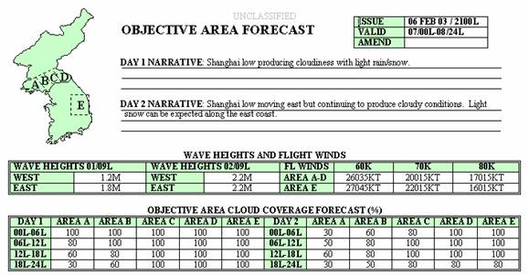
2.0. General: To provide 24 and 48 hour north Korean and DMZ cloud cover forecasts for U-2 reconnaissance flights. Forecasts will be used to help determine U2 reconnaissance flight routes and mission sensor selection. The forecaster will discuss the RECCE forecast with the C2, and provide them with a copy daily.
3.0. Procedures:
3.1. Forecast
Locations / Time Periods:
3.2. Forecasts will
be created for four specific areas in
3.3. The forecast
is broken up into four six-hour blocks for each day. Day 2 is used as a planning
outlook.
3.3.1. Day 1 begins
at 00L for the next 6 hours. The next block begins at 06L for the next 6
hours. Blocks 3 and 4 begin at 12L
and 18L respectively.
3.3.2. Day 2 is set
up exactly the same way as Day 1.
4.0. Daily Forecast
Preparation:
4.1. CC Seoul forecasters will use the forecast funnel process for the RECCE on the 607th Weather Squadron web page.
4.2. Surface
Observations: Surface observations,
both synoptic and METAR, will be used for trends. Fog formation and dissipation is one
such example that is crucial for reconnaissance and must be taken into account
by the forecaster and sensor operators.
4.3. Models: Forecast models such as GFS, NOGAPS, MM5
and ADVECT CLOUD (JAAWIN) will be used by the forecaster.
5.0. RECCE Objective Area Forecast.
5.1.The forecast is
valid for the next days 24
hour forecast (it also includes a 48 hours planning forecast). Parameters
forecast are:
5.2. Day 1 and 2
Narratives: This is a plain
language forecast of weather affecting the Objective Area during the next 48
hours.
5.3. Wave
Height. For continuity check
current wave height under the Industry link at http://w365.com/korea/eng/index_eng.html. Forecast graphics can be found on the
following URL: https://www.yoko.npmoc.navy.mil/npmocpl.htm.
For times, use 09L/00Z for the Day 1 and Day 2 forecast wave
heights. Forecast area locations
are 25nm east of RKNO and 25nm west of RKSP.
5.4. Winds
Aloft. Wind speeds and directions
are required for sixty, seventy, and eighty thousand feet. This is to be entered
in a five-digit format (i.e., 15015).
Areas A-D are separated from area E on the
worksheet. Use 09L/00Z for the valid time.
5.5 Cloud
forecast. The total cloud cover (to
include fog) is given in a percentage of 10 percent increments (i.e. 0, 10,
20, �100 percent). Persistence will be recorded as the
cloud cover (category 1, 2, or 3) at the time issuance.
5.5.1. A cloud
forecast is given for 24 and 48 hours. List the percentage of cloud cover
expected for each area and each time frame.
6.0. Timelines for RECCE Products.
6.1.
NLT 1330L- RECCE Objective
Area Forecast must be disseminated for the following
day.
6.2.
NLT 2230L � Send RECCE
Update
6.3.
NLT 0600L � Send RECCE
Update

7.0. Dissemination.
7.1. Normal dissemination
is done by e-mail to J2 Collection Management, the 607 AIS and HTACC
Weather.
7.2. When completed, 1 copy of the RECCE forecast will be printed out and given to the C2 officer
8.0. Back-up Dissemination Procedures.
8.1.
607AIS: Voice 784-5976 (fax 784-2039, used as a backup only
when email is down). You must fax (fax
784-2039, voice 784-8111/3025)
and email amendments.
8.2. HTACC
Weather: Voice 784-4133 (fax 784-6697, used as a backup only
when email is down).
8.3. J2 Collection
Management: Voice 723-3597 during
normal duty hours, 723-3609 after hours.
