Index

AIRBORNE RECONNAISSANCE SUB-DOMAIN ANNEX FOR THE C4ISR DOMAIN

DRAFT For Review Only. Not For Implementation.

DATE REVISED: 29 October 1997
REVISION HISTORY:
31 October 1997: JTA Version 2.0 - Second Draft
Includes the following major changes:
  1. AR Sub-Domain Annex modified to fit JTA V2.0 final format
  2. Citation of standards updated to conform to JTA guidelines
  3. Duplicate standard references with JTA core and C4ISR Domain Annex removed

Comments on the JTA can be submitted through,
or mailed to jta-comment@www.disa.mil

This annex is managed by the Defense Airborne Reconnaissance Office (DARO).

AR.1. AR SUB-DOMAIN ANNEX OVERVIEW

AR.1.1 BACKGROUND

This Airborne Reconnaissance (AR) Annex to the Joint Technical Architecture (JTA) has been developed to provide standards to the Defense Airborne Reconnaissance Programs (DARP). These standards are mandated in order to aid in the development of new AR systems (or major upgrades of legacy systems). In addition, the standards are designed to facilitate the exchange and exploitation of AR data across the Department of Defense (DoD), and, in Operations Other Than War (OOTW), to users outside of the DoD. These standards have been determined to be unique to the DARP acquisition, communications, data processing, and user workstation systems. Standards that are not unique to the DARP have been transferred into the C4ISR Domain Annex of the JTA.
The Airborne Reconnaissance Information Technical Architecture (ARITA) was the first attempt to consolidate all known airborne reconnaissance technical standards into a single document. The Airborne Reconnaissance Technical Architecture Working Group (ARTAWG) had representatives from the sensor, platform, communications, ground stations, and collection management/mission domains planning to consolidate AR standards. Based on the ARTAWG work, DARO published the ARITA in September 1996. The DARO promoted the ARITA as a stand-alone reference that incorporated much of the work from the JTA, Technical Architecture Framework for Information Management (TAFIM), and others, that applied towards airborne reconnaissance. In addition it also contained many standards that were unique to AR. During this time, the proliferation of numerous architectures was addressed by both Assistant Secretary of Defense for Command, Control, Communications and Intelligence (ASD(C3I)) and Office of the Secretary of Defense for Acquisition and Technology (OSD(A&T)). The ARITA was recognized as unique because it addressed both the Command, Control, Communications, Computers, and Intelligence (C4I) and the acquisition aspects of airborne reconnaissance systems. Therefore, the ARITA was deemed as a "pathfinder" for the larger architecture consolidation efforts within the DoD. As such, the Director DARO elected to migrate the ARITA to the JTA and discontinue publication of the ARITA as a stand-alone document.
This version of the sub-domain annex recognizes only standards that are mandated in addition to those found in corresponding sections of the C4ISR Domain Annex. The Defense Airborne Reconnaissance Office (DARO) is in the process of examining all DARP standards. As a result of this effort, future versions of the AR Annex will address standards that are exceptions to those found in the C4ISR Domain Annex. In addition, standards for the DARP that are not yet mature (under the rule set of the JTA), but are expected to develop into AR Annex mandated standards, will be placed in service area emerging standards sections of this annex.

AR.1.2 PURPOSE

The AR Annex supports four mutually supporting objectives that provide the framework for meeting warfighter requirements. First, the AR Annex provides the foundation for seamless flow of information and interoperability among all airborne reconnaissance systems and associated ground/surface systems that produce, use, or exchange electronic information. Second, it establishes the minimum set of standards and technical guidelines for development and acquisition of new, upgraded, and demonstration systems to achieve interoperability; with reductions in costs and fielding times that would be unachievable without a technical architecture. Third, it ensures interoperability within the Defense Airborne Reconnaissance Programs (DARP) and enables development of new or alternative connectivities and operational plans for specific mission scenarios for airborne reconnaissance systems. Finally, through coordination with other sections of the JTA, the AR Annex takes the first step in ensuring interoperability between DARP and other DoD systems. Specifically, it provides the framework for attaining interoperability with space-based and other intelligence, surveillance, and reconnaissance systems.

AR.1.3 SUB-DOMAIN DESCRIPTION

The AR Sub-Domain Annex to the JTA mandates the minimum set of standards and guidelines for Command, Control, Communications, Computers, Intelligence, Surveillance, and Reconnaissance (C4ISR) systems relating to manned and unmanned AR systems. The annex provides the technical foundation for migrating AR systems towards the objective architecture identified in the Integrated Airborne Reconnaissance Strategy and in the various program plan documents of the DARO. (Published DARO documents can be found at http://www.acq.osd.mil/daro on the World Wide Web.)
This AR Annex adds standards required for the airborne reconnaissance domain and is meant to complement both the C4ISR Domain Annex and the Defense Information Infrastructure Common Operating Environment (DII COE) as shown in Figure 1-1. The JTA (including the AR annex) and the DII COE supply the high level guidance to the two standards handbooks governing AR systems: the Joint Airborne Signals Intelligence (SIGINT) Architecture (JASA) Standards Handbook, and the Common Imagery Ground/Surface System (CIGSS) Acquisition Standards Handbook. These standards handbooks provide the most specific guidance for implementing the airborne efforts of the Imagery Intelligence (IMINT) and SIGINT communities and their corresponding umbrella programs. Airborne Measurement and Signature Intelligence (MASINT) standards will eventually be documented in the Joint Airborne MASINT Architecture (JAMA). An umbrella program, the Distributed Common Ground Systems (DCGS), has been proposed to eliminate potential duplication of IMINT, SIGINT, and MASINT ground station development. DCGS was chartered to develop a single ground system for these three intelligence areas under a common reference model.

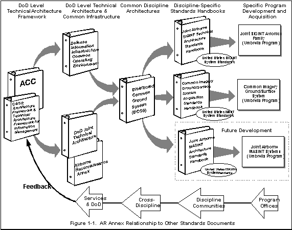
The DoD JTA AR Annex will be maintained by DARO through cooperation with the Architecture Coordination Council (ACC) and its associated steering groups and working groups. Questions or comments concerning technical details presented in this annex may be submitted to the ACC or directly to DARO.

AR.1.4 SCOPE AND APPLICABILITY

This part of the C4ISR Domain establishes the minimum set of rules governing information technology within airborne reconnaissance systems. The scope includes standards for information processing; information transfer; information modeling and information standards; human-computer interface standards; information security; standards for the sensor-to-platform interface; and collection management, mission planning, and control.
The airborne reconnaissance domain constitutes only a part of the larger surveillance and reconnaissance part of C4ISR. As such, this annex does not cover technical architecture details for any other part of the C4ISR spectrum other than the airborne reconnaissance portion. The annex has been derived from the ARITA, the most recent published DARO technical architecture document. This annex supersedes all draft and published versions of the ARITA. Future DARO technical architecture development and standards identification will merge within the greater C4ISR structure of the JTA. Because of the genesis of the AR Annex (from the ARITA), this version does not include any emerging standards. An ongoing effort by the DARO will identify emerging standards for future versions of the JTA.

AR.1.5 TECHNICAL ARCHITECTURE MODEL

As strictly defined by the C4ISR Integrated Architecture Panel, C4ISR Architecture Framework, "architectures" address multiple aspects crossing the boundaries of operational, technical, and system level architectures. The AR Annex focuses on the technical architecture level and specifically identifies only those standards that have a direct bearing on airborne reconnaissance systems.

In order to achieve the desired focus, the AR Annex uses a different reference model than the JTA technical reference model (TRM). This model variant is the AR Functional Reference Model (FRM). The complementary FRM and TRM frameworks (or perspectives) are used to present and discuss the technology and information standards selected for virtually any C4ISR system. The TRM, as derived from the TAFIM, is primarily a software-based model. It was originally developed for covering information technology within the DoD. Domain-specific standards, such as those required to cover all of airborne reconnaissance, do not fit fully within a software-based model. The FRM has therefore been adopted by DARO to encompass the airborne reconnaissance standards. It is used as a standards traceability matrix between the DARP architectures. The FRM depicts the generic, functional makeup of airborne reconnaissance systems and shows how the various functions are interrelated. It is particularly well suited for showing which specific technology standards apply to each functional area.

AR.1.5.1 Background for the AR Functional Reference Model

The AR FRM provides a common framework for defining the scope and functional makeup of airborne reconnaissance systems. The FRM is critical for selecting standards and effectively depicting where they must be applied in the overall framework. Based on the functional model developed by the JASA working group and approved by the Defense Airborne Reconnaissance Steering Committee (DARSC), the FRM incorporates additional functions found in IMINT and MASINT systems, explicit mission planning and control functions, and expanded communications functions for integrating airborne reconnaissance with warfighter and other C4I systems (e.g., command and control systems, air tasking, and collection management). The AR FRM is shown in Figure 1-2.

AR.1.5.2 AR FRM Traceability

In addition to this technical architecture, the DARO uses both operational and systems architectures to define and lead airborne reconnaissance systems. Both the operational and systems architectures will examine airborne reconnaissance using a functional flow approach. In each of these evolving architectures, there must be traceability back to standards as defined in this AR Annex FRM. Where the operational functional flow or the system functional flow cannot be traced back to a set of standards (i.e., a "block" as shown in the FRM illustration), the FRM will require updating. Similarly, where the FRM blocks cannot be traced to both an operational component and a system component, the operational or system architecture model will require updating. Thus, the FRM model, as used in the airborne reconnaissance technical architecture described in this annex, will provide a cross-comparison capability with other DARO architecture models.

AR.1.5.3 AR FRM Defined

The AR FRM is a generic model intended to show only functional flow; it does not depict actual implementations of airborne reconnaissance systems. The generic model is intended to encompass all aspects of an airborne reconnaissance architecture that will meet the needs of manned aircraft and Unmanned Aerial Vehicles (UAVs) as well as their sensors and associated ground/surface systems. The AR FRM shown in Figure 1-2 breaks out the overall functional components into the seven distinct areas identified in Table 1-1.

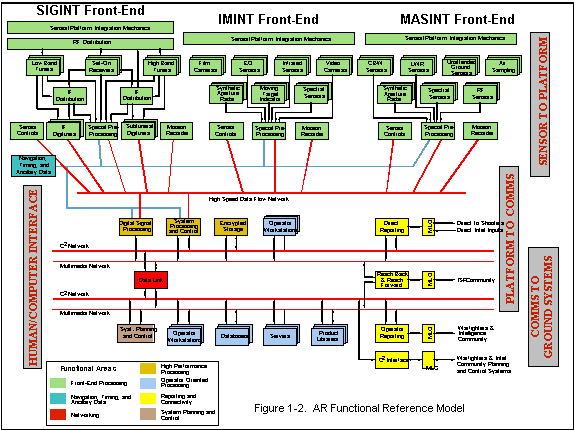
Table 1-1. AR FRM Functional Components

Front-end processing functions

Navigation, timing, and ancillary data

Networking functions

High performance processing functions

Operator-oriented processing functions

Reporting and connectivity functions

System planning and control functions

The seven functional areas provide a convenient representation of the flow of information through airborne reconnaissance systems. At the top level, the three primary sources of AR data are shown (signal, imagery, and measurement & signature intelligence). Data from each of these types of front-end processors flow down through the system until the data can eventually be exploited at an analyst workstation. Each step of this flow-down process represents an interface where standards are required to ensure interoperability. In Figure 1-2, these interfaces are depicted where two of the separate functional areas connect (as shown via a grayscale/color change). While useful for driving the interface requirements, dividing the mandated standards across the seven functional area shown in Table 1-1 can cause confusion from an implementation viewpoint. For documentation and implementation, it is easier to list the resulting requirements by looking at the standards across a broader interface definition. This AR Annex groups the seven functional areas logically into the four categories of Sensor to Platform Standards, Platform-to-Communications Standards, Communications-to-Ground Systems Standards, and Human/Computer Interfaces Standards. These four major groupings are shown in the gray rectangles placed vertically in Figure 1-2. This version of the AR Sub-Domain Annex identifies standards for three of these categories: Human/Computer Interface (Section 2.5 of this sub-domain annex), Sensor to Platform (Section 2.7 of this sub-domain annex) and Communications-to-Ground Systems. All of the identified communication-to-ground system standards fall within Collection Management, Mission Planning, and Control service areas (Section 2.8 of this sub-domain annex). Future versions of this sub-domain annex will add service areas for the Platform-to-Communications category.

AR.1.6 ANNEX ORGANIZATION

The organization of this annex is intended to mirror the organization of the C4ISR Domain Annex to the greatest extent possible. Each section of the annex, except for Part 1 (Overview), is divided into five subsections as follows. The first subsection, introduction, is for informational purposes only. It defines the purpose and scope of the subsection and provides background descriptions and definitions that are unique to the section. The second subsection is a paragraph placeholder for exceptions to the standards in the corresponding service areas of the JTA Core and the C4ISR Domain. At present, there are no exceptions identified in the AR Sub-Domain Annex. The third subsection contains a minimum set of mandated standards for the identified service area. The subsection also identifies mandatory standards profiles and practices that are applicable to the AR domain. Each mandated standard or practice is identified as a bulleted item on a separate line and includes a formal reference citation that can be included within Requests for Proposals (RFP) or Statements of Work (SOW). Subsection four contains a paragraph placeholder for extensions to the standards identified in the corresponding service areas of the JTA Core and the C4ISR Domain. At present, there are no extensions identified in the AR Sub-Domain Annex. The final subsection, Emerging Standards, provides an abbreviated description of candidates that are expected to move into the mandated subsection within a short period. As defined within the core of the JTA, this transition should occur within three years of publication of the standard in the emerging subsection.
The AR Annex contains three parts. Part 1 is the Overview. Part 2 contains the Standards for the DARP corresponding to the JTA Core (and C4ISR Domain) service areas that are taken as exceptions, additions, or extensions. Part 2 also contains emerging standards for the AR Sub-Domain Annex. Part 3 contains the Standards for the DARP for service areas that are not included in the JTA Core or C4ISR Domain Annex. The acronym list for the AR Annex has been incorporated into the larger JTA list (Appendix A). Similarly, a summary of AR mandated standards for each service area has been incorporated into Appendix B of the JTA. Table 1-2 identifies the service areas for this sub-domain annex. This table also indicates whether the AR annex service area has a corresponding service area in the C4ISR Domain Annex of the JTA or whether the service area is unique to the DARP. Table 1-2 also identifies whether this version of the AR Sub-Domain Annex includes any service-unique items for the DARP or whether the paragraph is merely a placeholder for this version of the document.

Table 1-2. AR Annex Part 2 Sections
Section Service Area Corresponding
JTA Service Area
DARP-Unique
Service Area
Exceptions, Additions,
or Extensions Identified
2.2 Information Processing
*

*
2.3 Information Transfer
*

*
2.4 Information Modeling & Information
*


2.5 Human Computer Interfaces
*

*
2.6 Information System Security
*


2.7 Sensor Platform Interface
*

2.8 Collection Management, Mission
Planning & Control

*


AR.2. EXCEPTIONS AND ADDITIONS TO C4ISR DOMAIN SERVICE AREAS

AR.2.1 INTRODUCTION

This Airborne Reconnaissance Subdomain Annex, in conjunction with the DoD Joint Technical Architecture, provides the technical foundation for migrating airborne reconnaissance systems towards the objective architecture identified in the various program plan documents of the Defense Airborne Reconnaissance Office. DARO's high-level vision of the migration plans and major thrusts to achieve the capabilities, connectivities, and interoperability required of airborne reconnaissance systems has now moved forward by merging ISR systems within the C4I structure described in the domain annex of the JTA. This merger is made with the full knowledge that ISR systems are not, as of today, a simple extension of the JTA but rather, a broad expansion of the concept of C4I interoperability. The migration from today's stove-piped systems to achieving the concepts promulgated by C4I For The Warrior, other DoD technical architectures, and Service/Agency operational architectures requires DARO and the ISR community to take this step. This part of the AR Sub-Domain Annex establishes the minimum set of rules governing information technology within airborne reconnaissance systems. The scope includes standards for information processing; information transfer; information modeling and information standards; human-computer interface standards; information security; standards for the sensor-to-platform interface; and collection management, mission planning, and control. This part of the AR Annex does not contain rules for the physical, mechanical, or electrical components of systems, even when these are related to information technology.

AR.2.2 INFORMATION PROCESSING STANDARDS

AR.2.2.1 Introduction

This Annex expands the concept of information within a C4I system to include the information processing of ISR sensor systems. Much of this processing is embedded within the sensor systems themselves and the avionics on board reconnaissance assets. It is important to note that ISR systems encompass both real time and non real time architectures. The sensor, platform, telemetry, and data link systems within ISR are all real time, embedded systems that require speeds at least three orders of magnitude higher and deterministic scheduling. The TAFIM TRM, adopted for use by the JTA, does not accommodate real time and embedded systems. On the other hand, once raw data is delivered to the ground, non-real time processing and dissemination systems follow the current JTA/TRM model.
As intelligence time lines continue to shrink to weapons system (shooter) time lines, speed will become even more critical for operational systems. Much of this architecture is based on real time processing and does not follow the Technical Reference Model described in the JTA. For weapons systems models, whether it be a tank or an aircraft, real time systems may be closer to the Society of Automotive Engineers (SAE) Generic Open Architecture (GOA) as referenced in Annex F of the Army Technical Architecture. The DII COE is also working towards a DoD-wide real time architecture model. Ongoing work by the Defense Information Systems Agency (DISA) TRM Working Group will resolve this disconnect in a manner that, if possible, accommodates both weapon systems and C4I systems.
User requirements for specific ISR missions define information processing within the three intelligence disciplines (IMINT, SIGINT and MASINT) as defined below. These standards encompass all software in associated ground/surface systems as well as embedded in airborne reconnaissance systems.

AR.2.2.2 Mandate Exceptions

There are no AR Sub-Domain exceptions to the standards identified in this C4ISR Domain service area.

AR.2.2.3 Mandate Additions

AR.2.2.3.1 Image Processing

This AR Annex defines image processing as the conversion of raw data into a product that can be exploited. Imagery is defined as any Electro Optical (EO), Infrared (IR), or Synthetic Aperture Radar (SAR) data stream collected by an imaging sensor that can be visualized on an exploitation terminal. The sequence of steps needed to extract information and prepare an exploitation product depends upon the required external environment interface (EEI), the shapes of the objects in the scene, illumination and shadows, and military and physical contexts.
AR.2.2.3.1.1 Imagery Archives
The primary function for product libraries is to maintain a complete set of all reconnaissance products produced (in a given system) and make them available to all potential users on a query or browse basis. Although the products may include conventional formatted message reports, product libraries are most useful for disseminating newer "specialized" products such as video and audio clips, imagery, graphics, multi-media, and hypertext products like those available on the Internet. Dissemination of these products and access to the product libraries will be through the Internet protocol router networks such as NIPRNET, SIPRNET, and JWICS. Although there are no mandated standards for this area, compatibility with the NIMA Library Program (NLP) [formerly Image Product Archive (IPA) and Image Product Library (IPL)] is required. The NLP is described in the US Imagery and Geospatial Information System (USIGS) Technical Architecture.
AR.2.2.3.1.2 Common Imagery Ground Surface System (CIGSS)
The CIGSS concept, which is now a segment of the DCGS described in Part 1, has been approved by the JROC and is fully supported by the Services. It is not a system in the traditional sense; instead, CIGSS is an umbrella program that defines interoperability, performance, and commonality requirements and standards for DoD ground/surface based imagery processing and exploitation systems. It consolidates the systems listed in Table 2-1 into a single DARP project.

Table 2-1. CIGSS Component Programs

Joint Service Image Processing System (JSIPS) program - including Navy, Air Force, and Marine Corps

Army's Enhanced Tactical Radar Correlator (ETRAC)

Army's Modernized Imagery Exploitation System (MIES)

Imagery parts of the Air Force's Contingency Airborne Reconnaissance System (CARS)

Marine Corps' Tactical Exploitation Group (TEG) programs

Korean Combined Operational Intelligence Center (KCOIC) imagery systems

Pacific Air Forces Interim National Exploitation System (PINES)

Mobile Intelligence Processing Element (MIPE)

Integrated Deployable Processing System (IPDS)

Processing/exploitation capability for the U-2R SENIOR YEAR Electro-Optical (E/O) sensor (SENIOR BLADE)

CIGSS-compliant (mandated) systems are designed to receive, process, exploit and disseminate imagery products derived from satellites, commercial or foreign satellite sensors, UAV, U-2 reconnaissance aircraft and tactical aircraft such as the F/A-18. As part of the overall United States Imagery and Geospatial Information System (USIGS) community of exploiters and producers, CIGSS will be afforded increased flexibility and capability in satisfying multiple time-sensitive user needs. Once compliant with common community processing, storage, retrieval, and dissemination standards, CIGSS modularity will enable the theater, JTF and components to employ interactive CIGSS elements for small regional contingencies and major regional conflicts from a variety of sources to meet the anticipated intelligence demand. This annex mandates the standards identified in the most current approved handbook for airborne IMINT:

AR.2.2.3.2 SIGINT Information Processing

The Joint Airborne SIGINT Architecture (JASA) is the DoD's plan for meeting the warfighter's 2010 and beyond airborne SIGINT requirements. The fundamental philosophy behind JASA is to leverage commercial digital signal processor technology to address the ever growing population of varied radio frequency (RF) signals, modulation schemes and signal multiplexing structures. By digitizing the signal early in the sensor system, common hardware processing can be used that is independent of signal type, reducing the need for signal specific specialized hardware. This approach to signal processing increases the flexibility and overall capacity of the SIGINT system, which must rapidly respond to the explosion of digital signals in the environment.
Version 1.0 of the JASA Standards Handbook developed by the JASA Standards Working Group was published in July 1996 with the new version currently in draft. This annex mandates the standards identified in the most current approved handbook for airborne SIGINT:

AR.2.2.3.3 Data Management

Airborne Reconnaissance data management supports the definition, storage, retrieval, and distribution of data elements (e.g., imagery and support data) derived from data collected by airborne sensors and shared by multiple applications/systems.
AR.2.2.3.3.1 Target/Threat Data Management
The National Target/Threat Signature Data System (NTSDS) has been designated as a migration system, in accordance with guidance from ASD(C3I) and by the Intelligence Systems Board (ISB). NTSDS provides the DoD signature data community (ISR, MASINT, & Armament) signature data from multiple, geographically distributed sites via a unified national system. NTSDS Data Centers employ standard data parameters and formats for stored target signatures for national and DoD customers. There are no AR Annex mandates for target/threat data management. However, compatibility with the National Target/Threat Signature Database System is required.
AR.2.2.3.3.2 Data Management Services
These services support the definition, storage, and retrieval of data elements from monolithic and distributed, relational Database Management Systems (DBMSs). These services also support platform-independent file management (e.g., the creation, access, and destruction of files and directories). This annex follows the JTA core that mandates conformance to entry level ANSI Structured Query Language (SQL) standards and adds Ada interfaces. The following standards are mandated for the AR community:
AR.2.2.3.3.3 Distributed Computing Services
These services allow various tasks, operations, and information transfers to occur on multiple, physically-dispersed or logically-dispersed, computer platforms. These services include but are not limited to global time; data, file and name services; thread services; and remote process services. This standard is mandated in the AR community in addition to the standards mandated in the JTA core:

AR.2.2.4 Mandate Extensions

There are no AR Sub-Domain extensions to the standards identified in this C4ISR Domain service area.

AR.2.2.5 Emerging Standards

This version of the AR Annex does not identify any emerging standards for information processing. An ongoing effort by the DARO will identify emerging standards for future versions of the JTA.

AR.2.3 INFORMATION TRANSFER STANDARDS

AR.2.3.1 Introduction

Near-real-time dissemination of Joint Service tactical intelligence information hinges on information transfer standards. To ensure continued battlespace awareness and to satisfy the requirement for secure, high-speed, multi-media transmission services, an integration of several intelligence broadcasts into one standard system is probable.
Information transfer standards and profiles are described in this section cover dissemination and data link mandates for ISR systems. This section identifies systems and the interface standards that are required for interoperability between and among ISR systems and are in addition to the systems described in JTA Core and the C4ISR Domain. It does not cover standards for platform internal information transfer. These standards will instead be covered in the Sensor to Platform service areas of this sub-domain annex.

AR.2.3.2 Mandate Exceptions

There are no AR Sub-Domain exceptions to the standards identified in this C4ISR Domain service area.

AR.2.3.3 Mandate Additions

AR.2.3.3.1 Dissemination Systems

This section focuses on standards supporting near-real-time battlefield dissemination of intelligence and surveillance products from both airborne platforms and ground surface systems. Broadcasts give tactical users a "picture of the battlefield." Depending on the system, displays or messages can include data derived from SIGINT, IMINT, or MASINT systems as well as support for targeting, situation awareness, battle management, survivability, and mission planning. Together these standards reflect the diverse needs addressed by Joint users. There are no additional dissemination system standards mandated in this annex. However, compatibility with the systems identified in Table 2-2 are required.

Table 2-2. Airborne Reconnaissance Dissemination Systems

Joint/Global Broadcast Service (JBS/GBS)

Tactical Information Broadcast Service (TIBS)
Tactical Receive Equipment and Related Applications (TRAP) Data Dissemination System (TDDS).
Tactical Reconnaissance Intelligence Exchange System (TRIXS)

AR.2.3.3.2 Data Link Standards

The Common Data Link (CDL) is a full duplex, jam resistant, point-to-point, microwave communications system developed by the Government for use in imagery and signals intelligence systems. It provides an interoperable, high bandwidth, digital data link for air-to-ground, air-to-surface, and air-to-satellite (relay) communications in airborne reconnaissance systems. The term CDL refers to a family of interoperable data links offering alternate levels of capabilities for different specific applications. Specific functions identified for airborne reconnaissance include the Modernized Interoperable Surface Terminal (MIST), the Tactical Interoperable Ground Data Link (TIGDL), and the Common High Bandwidth Data Link Surface Terminal (CHBDL-ST) and their corresponding Interface Control Documents (ICD). There are presently efforts within DARP to standardize the different data link standards into a single standard. In the interim, the following standards are mandated as follows:
For a unified configuration control and standardized communications paths between multiple sensors: For requirements to downlink Advanced Tactical Air Reconnaissance System (ATARS) and Advanced Synthetic Airborne Radar System to the Tactical Exploitation Group (TEG):

AR.2.3.4 Mandate Extensions

There are no AR Sub-Domain extensions to the standards identified in this C4ISR Domain service area.

AR.2.3.5 Emerging Standards

The airborne reconnaissance dissemination systems listed in Table 2-2 are to be replaced by the Integrated Broadcast Service (IBS) over the next five years. The IBS IOC is expected in 2002.

AR.2.4 INFORMATION MODELING AND INFORMATION STANDARDS

AR.2.4.1 Introduction

AR.2.4.2 Mandate Exceptions

There are no AR Sub-Domain exceptions to the standards identified in this C4ISR Domain service area.

AR.2.4.3 Mandate Additions

This version of the AR Annex does not specify any additional standards for information modeling and information.

AR.2.4.4 Mandate Extensions

There are no AR Sub-Domain extensions to the standards identified in this C4ISR Domain service area.

AR.2.4.5 Emerging Standards

This version of the AR Annex does not identify any emerging standards for information modeling and information. An ongoing effort by the DARO will identify emerging standards for future versions of the JTA.

AR.2.5 HUMAN COMPUTER INTERFACES

AR.2.5.1 Introduction

This subsection identifies the mandatory standards, profiles, and practices for human-computer interfaces. The human computer interface is an extremely important AR function. It is an area that is evolving quickly due in large part to rapid advances in commercial video technologies. These commercial interfaces have been released to the public only to be replaced in a very short time by the next generation of products. This rapid pace has produced few standards. However, the speed of technology advance is expected to produce several breakthroughs for information/understanding transfer to reconnaissance operations.

AR.2.5.2 Mandate Exceptions

There are no AR Sub-Domain exceptions to the standards identified in this C4ISR Domain service area.

AR.2.5.3 Mandate Additions

Currently, the ISR community has additional standards, beyond those in the core of the JTA, for imagery display systems.

AR.2.5.3.1 Graphics Services

These services support the creation and manipulation of graphics. They include device-independent, multidimensional graphic object definition, and the management of hierarchical database structures containing graphics data. This annex follows the JTA core (Graphics Services) that mandates standards for non-COTS. The following standard is mandated for the AR community:

AR.2.5.4 Mandate Extensions

There are no AR Sub-Domain extensions to the standards identified in this C4ISR Domain service area.

AR.2.5.5 Emerging Standards

This version of the AR Annex does not identify any emerging standards for human computer interfaces. An ongoing effort by the DARO will identify emerging standards for future versions of the JTA.

AR.2.6 INFORMATION SECURITY STANDARDS

AR.2.6.1 Introduction

Information security standards protect information and the processing platform resources. They must often be combined with security procedures, which are beyond the scope of the information technology service areas, to fully meet operational security requirements. Security services include security policy, accountability, assurance, user authentication, access control, data integrity and confidentiality, non-repudiation, and system availability control. The mandated and emerging standards identified in Section 6 of the JTA apply to the AR Annex. ISR reporting includes dissemination of formatted message traffic, imagery, imagery products, database transaction updates, and graphical situation display data. In general, these products are widely disseminated through the DoD communications infrastructure.

AR.2.6.2 Mandate Exceptions

There are no AR Sub-Domain exceptions to the standards identified in this C4ISR Domain service area.

AR.2.6.3 Mandate Additions

Intelligence information can be disseminated from Unclassified to TS/SCI. For the AR domain, there are presently no additions or exceptions to the information security mandates listed in the JTA core.

AR.2.6.4 Mandate Exceptions

There are no AR Sub-Domain extensions to the standards identified in this C4ISR Domain service area.

AR.2.6.5 Emerging Standards

This version of the AR Annex does not identify any emerging standards for information security. An ongoing effort by the DARO will identify emerging standards for future versions of the JTA.

AR.2.7 SENSOR-TO-PLATFORM INTERFACE

AR.2.7.1 Introduction

This section identifies the minimum standards for airborne sensors and the interface to the airborne sensor platforms. These interfaces allow sensor data, both raw and pre-processed, to transfer through airborne communications/telemetry systems and to mission recording equipment. Conversely, aircraft data such as navigation, timing, or telemetry inputs to control on-board sensors (e.g., optics, SAR spot coverage) must pass through this interface as well. Eventually, the interfaces will become more platform independent and sensor system independent as these standards evolve towards open systems.
Airborne reconnaissance sensors are the source of all ISR information. Their output, combined with on-board flight information such as position and altitude, produces a raw data set that is normally not considered useful information until it is processed and disseminated to the warfighter consumer. Much of this processing is done on board within real time systems and these must interface seamlessly within the host aircraft. This section lists standards that apply to that interface.
This section addresses the critical components of the interface between the sensor system and the host aircraft. This interface includes sensor to external environment, sensor control, data recording, aircraft power, navigation/flight data information to the sensor system, timing, internal communications, avionics busses and back planes, telemetry, and sensor preprocessing. Sensor systems have been divided into imagery, signals, and MASINT.

AR.2.7.2 AR Mandates

AR.2.7.2.1 Sensor Mandates

All airborne reconnaissance systems begin with a platform-integrated SIGINT, IMINT, or MASINT sensor. The specific functions of the front-end sensors are completely different and are discussed separately within the following subsections.
AR.2.7.2.1.1 IMINT
IMINT front-end functions are divided into ten major areas: seven image acquisition sensors, sensor control functions, special pre-processing functions, and mission recorders. The following subsections describe IMINT sensors and the specific standards that apply.
AR.2.7.2.1.1.1 Video Cameras
Legacy AR video systems currently use analog components. For analog systems, the base video standard is the National Television Standards Committee (NTSC) signal provided in RS-170 format. Commercial industry is currently migrating away from analog video components to all-digital systems. Airborne reconnaissance systems will leverage advances in commercial television technology that provides the standards for interoperability for commercial broadcast and military video systems. AR systems should provide a clear migration path toward an all-digital system, conforming to the mandated standards of the JTA core. There are no additional video camera standards mandated for the AR community.
AR.2.7.2.1.1.2 Image Quality Standards
Image quality is the single most critical factor determining the utility of the image for data exploitation. Image quality is dependent upon physical features of the collection system (e.g., focal length, lens quality, number and spread of multispectral sensors, and density of the sensor array), the geometric relationships at the time of imaging (e.g., distance and angle between the sensor and the target), target and transmission media features (e.g., acquisition angle and degree of illumination, image degradation from cloud cover and smoke), and errors introduced in the processing stream (e.g., data dropouts and "noisy" communication paths). The user communities for panchromatic, multispectral and radar imagery have developed a series of scales to rate the quality of the received imagery. These scales condense the many factors influencing the image into a single rating that defines the overall usability of the image. Common rating scales include the National Imagery Interpretability Rating Scale (NIIRS) for optical imagery, National Radar Imagery Interpretation Standard (NRIIS) for Synthetic Aperture Radar, and Multispectral Imagery Interpretability Rating Scale (MSIIRS) for spectral imagery.
For video imagery systems, the "DoD/IC Video Imagery Standards Profile (VISP)," Version 1.1, 26 September 1997, defines a "Video Systems (Spatial and Temporal) Matrix" (VSM). This Recommended Practice gives user communities an easy to use, common shorthand reference language to describe the fundamental technical capabilities of DoD/IC video imagery systems. The "Video Systems Matrix" includes tables of Technical Specifications and related Notes.
There are no AR community mandated standards for image quality.
AR.2.7.2.1.1.3 Synthetic Aperture Radar
Synthetic Aperture Radar (SAR) is the most commonly used type of radar for imagery reconnaissance applications. The systems are called synthetic aperture because the combination of the individual radar returns effectively creates one large antenna with an effective aperture size equivalent to the flight path-length traversed during the signal integration. The formation of this large synthetic aperture is what enables these radars to produce images with fine in-track (for azimuthal) resolution. The high bandwidth and pulse repetition interval enables the SAR's fine cross track (or range) resolution. The image can be produced with ground resolutions less than one foot, when operating in "spot" mode, and approach photographic appearance and interpretability. In search modes, ground sample distance (more correctly radar impulse response) is often ten feet or more. The following standards are mandated for the AR community:
  • Kalman filtering for navigation and timing, as defined in Kalman, R.E., A new approach to linear filtering and prediction problems, Trans. ASME, Series D, J. Basic Eng., V. 82, March 1960
    AR.2.7.2.1.2 SIGINT

    SIGINT front-end standards are concerned primarily with on-board systems that receive and process radio frequency (RF) from low frequency (LF), 30 kHz to 300 kHz, through extra high frequency (EHF), 30 GHz to 300 GHz, received by the platform antenna/antenna arrays. These RF antenna/antenna array types may be omni-directional, directional, beam-steered, steered dish, interferometric, or spinning dish. In addition, the SIGINT front-end functional elements include the RF distribution, low and high band tuners, set-on receivers, IF distribution IF digitizers, and sub-band tuners/digitizers, and channelizers. SIGINT sensor/platform interface standards are identified in the following reference:

    AR.2.7.2.1.3 MASINT
    Two important distinctions between MASINT and other intelligence systems are the maturity and diversity of the component systems. MASINT technologies are both immature and diverse. The MASINT discipline encompasses the seven technological areas of remote sensing identified in Table 2-3. Within each of the seven areas there are numerous implementations, many of which are still in the research and development phase, which makes the creation of standards a much more difficult task. Where possible, standards for MASINT systems will specified in this document. This version of the AR annex only identifies a single standard for unattended MASINT sensors.

    Table 2-3. MASINT Technology Areas

    Chemical and Biological Weapons (CBW)

    LASINT/Laser Warning Receivers (LWR)

    Unattended Ground Sensors (UGS)

    Spectral (Non-literal)

    Air Sampling

    Radio Frequency (RF)

    Synthetic Aperture Radar Phase History (SAR PH)

    The Joint Airborne MASINT Architecture (JAMA) is a much needed effort to define the overall architecture for airborne MASINT systems and the corresponding standards. The JAMA, when initiated, will be fully integrated with JASA where RF MASINT and SIGINT systems overlap. Similarly, the SAR PH and spectral MASINT airborne areas will be fully coordinated with CIGSS to maximize intelligence assets.
    AR.2.7.2.1.3.1 Unattended MASINT Sensors
    Unattended MASINT Sensors (UMS) are small, autonomously powered, disposable systems that can be emplaced by airborne platforms or hand emplaced. UMS can contain one or more types of sensors (seismic, acoustic, IR, magnetic, chemical, or radiological) that transmit alarm messages or data when triggered by enemy activity. The SEIWG-005 standard specifies the frequencies, data formats, and protocols for this class of sensors in order to relay the data back via communication links and data relays, to a common exploitation station. The following UMS standard is mandated for AR systems:

    AR.2.7.2.2 Airborne Platform Mandates

    This AR Annex does not cover the technical architecture details for the airborne platform except for those details that directly affect the on-board reconnaissance sensors and the processing of the collected data stream. Power, timing, and navigation standards are critical for the operation of the sensors, the transmission of data, and the exploitation of the gathered information.
    AR.2.7.2.2.1 Sensor/Platform Aircraft Power

    Airborne ISR sensor systems, other than battery-driven systems, must be designed to operate on standard aircraft electrical power. MIL-STD-704E is the governing standard for all manned platforms, whereas JII 91081 governs the power interface design for all unmanned platforms. The following standards are mandated for AR systems:

    AR.2.7.2.2.2 Timing
    Timing is critical for airborne sensor systems and directly affects the overall quality of the finished airborne reconnaissance product. All processing and exploitation functions use timing data in some way when processing the sensor data. The following timing standards are mandated for AR systems:
    AR.2.7.2.2.3 Navigation, Geospatial
    Navigation service provides information about the position and attitude (roll, pitch and yaw) of the collection platform. Navigation and geospatial data are parts of the metadata associated with sensor data, and are critical to sensor data exploitation. The following navigation and geospatial standards are mandated for AR systems:
    AR.2.7.2.2.4 Airborne Platform-Internal Communications
    Internal communications for on-board networks are used to apply real time commands to control on-board sensors, distribution of raw/pre-processed digital sensor data between processing components, and metadata tagged to the sensor data. The numerous standards referenced below must be selected based on the platform. Their selection depends on whether the end platform is an unmanned aerial vehicle or manned vehicle. For example, most UAVs will not require a LAN capacity needed for a Rivet Joint or AWACS. Depending upon the application environment, one of more of the following mandated standards shall be selected for AR systems:

    AR.2.7.2.3 Air Vehicle/Sensor Telemetry Mandates

    Commands to various SIGINT, IMINT, and MASINT front-end equipment flow through airborne telemetry systems to on-board LANs. Sensor commands and acknowledgments may include position changes, mode changes, fault isolation commands, and others. The mandated telemetry standards for both manned and unmanned systems are:
  • Telemetry Group, Range Commanders Council, Telemetry Standards, IRIG 106-96, Secretariat, Range Commanders Council, U.S. Army White Sands Missile Range, New Mexico, Chapter 4, Pulse Coded Modulation Standards, Chapter 8 - MIL-STD-1553 Department of Defense Interface Standard for Digital Time Division Command/Response Multiplex Data Bus, 21 September 1978

    AR.2.7.2.4 Mission Recorder Mandates

    Mission recorders are used to capture the raw, pre-processed sensor data together with associated navigation, timing, and ancillary data. Additionally a computer controlled interface for basic recorder functions such as start, stop, shuttle, fast forward, and rewind is included.
    In conjunction with recording the raw sensor data, timing data will be recorded (on a separate track) in accordance with the standards defined below. The IRIG-B standard was written specifically for magnetic tape storage, but it is applicable to disk storage media as well. In conjunction with the migration to all digital systems, mission recorder standards will be reevaluated to emphasize digital and de-emphasize analog. Selection of the appropriate standard from those that follow is dependent upon application requirements.
    Based on the application environment, the following mission recorder standards are mandated for use in AR systems:

    High data rate digital imagery:


    Analog video:
    Digital Video:
    SIGINT payloads:

    AR.2.7.3 Emerging Standards

    This version of the AR Annex does not identify any emerging standards for the sensor platform interface. An ongoing effort by the DARO will identify emerging standards for future versions of the JTA.

    AR.2.8 - COLLECTION MANAGEMENT, MISSION PLANNING & CONTROL

    AR.2.8.1 Introduction

    This annex defines standards for collection management, mission planning and mission control which are integral parts of airborne reconnaissance systems. Collection management is a process that is performed by a Collection Management Authority (CMA) who uses a specific collection management system. Mission planning is a process that may be performed within an airborne reconnaissance system or it may be performed externally. Mission control is a process that deals with execution of specific reconnaissance missions.

    AR.2.8.2 AR Mandates

    AR.2.8.2.1 Collection Management Mandates

    Collection requirements are generated by warfighters and then allocated to Collection Management Authority (CMA). The CMA uses the Joint Collection Management Tool (JCMT) to provide an overview of the requirements database. JCMT assists the CMA in determining the appropriate collection platform or mix of assets required to perform the mission. The CMA's collection management system provides the reconnaissance feedback to the warfighters who originated the requests for information. JCMT is the migration system designated by the DoD to be used for all-source management functions (i.e., legacy systems will be phased out as JCMT supersedes them). As such, it will combine IMINT, SIGINT, MASINT, and HUMINT tasking.
    On 28 October 1994, the Assistant Secretary of Defense for Command, Control, Communications and Intelligence (ASD(C3I)) approved the recommendations from the Intelligence Systems Board Migration Panel that: 1) JCMT become the DoD Intelligence Information System (DODIIS) migration system for all-source collection management, and 2) the Army's Collection Management Support Tools (CMST) become the initial baseline for JCMT. According to ASD (C3I) direction, migration systems are to replace all legacy systems in FY97. Besides CMST, the legacy systems which JCMT will replace include DIA's Collection Requirements Management Application (CRMA), USAF National Air Intelligence Center's (NAIC) Collection Requirements Management System (CRMS), Operational Support Office's (OSO) UNIX-based National Exercise Support Terminal (UNEST), and SOUTHCOM's Intelligence Support Processing Tool (ISPT)
    For the AR domain, there are presently no additions nor exceptions to the collection management standards mandated in the JTA core. However, compatibility with the Joint Collection Management Tool (JCMT) is a requirement.

    AR.2.8.2.2 Mission Planning Mandates

    A multitude of mission planning systems exist today. Many of these are special applications that were designed for specific aircraft and operate on specific hardware suites. There are formal, programmatic efforts underway to consolidate these into several generic systems. Two of these were picked as representative systems for purposes of developing this annex: the Navy's TAMPS and the Air Force's AFMSS. Note that other specific mission planning systems have been consolidated into these two programs. TAMPS consists of a core and a number of mission planning modules for specific Navy, Marine Corps, and Coast Guard aircraft and weapons. AFMSS contains a core and a number of Avionics/Weapons/Electronics (AWE) modules for specific Air Force, Army, and US Special Operations Command aircraft and weapons. Long-term plans call for combining these into one DoD-wide mission planning system.
    While both the TAMPS and AFMSS programs show plans to provide mission planning capabilities for reconnaissance platforms (such as the U-2, UAVs, RC-135, EP-3, F/A-18 and others), the plans are generally for platform and navigation planning only (e.g., flight path, threat avoidance, take-off and landing calculations, or fuel consumption). Mission planning modules for the reconnaissance sensor system payloads and communications system planning are currently not in the baseline.
    The interfaces required for mission planning functions vary depending on specific system operational requirements and mission needs. For example, systems operated by the USAF will receive intelligence data from the unit-level Combat Information System (CIS), whereas the Army will generally rely on their All Source Analysis System (ASAS). Regardless of the source of the data, it will generally be received in airborne reconnaissance systems through the command and control interfaces or via bulk digital media such as magnetic tape and CD-ROM. There are no mandated mission planning standards for the AR domain. However, depending upon the service supported by the reconnaissance asset, compatibility with the Air Force Mission Support System (AFMSS), the Tactical Aviation Mission Planning System (TAMPS), the USAF Combat Information System (CIS), or the USA All Source Analysis System (ASAS) is essential.
    This version of the AR Annex does not identify any mandated standards for mission planning.

    AR.2.8.2.3 Mission Control Mandates

    Mission control functions provide for real-time and near-real-time control of the platform, sensor suite, and communications subsystems during the execution of reconnaissance missions. These control functions are implemented in ground/surface subsystems and consist of three types: remote piloting functions and telemetry data, remote sensor control functions, and dynamic retasking functions.
    Currently, there are no standards in this annex for manned aircraft. However, for remotely piloted UAVs, telemetry data are transmitted to the ground/surface system and piloting commands are transmitted to the vehicle via the data link in real-time. For UAVs, the Mission Planning and Control Station (MPCS) consists of the equipment necessary to perform mission planning, mission control, communications and data exploitation for one or more UAVs. Mission control includes the capability to hand over or take control of another UAV to/from another MPCS and prepare or process all the data which must be transmitted to the air vehicle to conduct the mission. The telemetry data essentially provides the same data that would otherwise be displayed to a cockpit pilot, but it is processed and displayed on ground-based equipment. As an aide to the ground-based "pilot," telemetry data also includes real-time video (e.g., in the visible part of the spectrum). The remote piloting functions are also used to facilitate take-of and landing for UAVs that may otherwise operate autonomously by executing programmed flight and sensor operations plans.
    Remote sensor control functions serve to extend real-time, direct control of the collection equipment to operators stationed in ground/surface systems. Remote commands may include, for example, turning receivers, aiming directional antenna, changing sensor modes, pointing cameras, adjusting focal length and exposure, setting on-board processing parameters, and a host of other operator-controlled functions. The MPCS is capable of receiving, storing, displaying, and exploiting Modular Mission Payloads (MMP) data received from the Air Vehicle (AV), reformatting the data and transmitting that data to appropriate internal and external users. The MPCS manages the data link and controls the data link operating parameters.
    Dynamic retasking functions enable reconnaissance operations to be changed in near-real-time by designated users/operators. Changes may affect the platform, such as navigating to a new track (flight path), or they may affect the sensor suites, such as switching SAR modes or switching from SIGINT to imagery collection. The following standards are mandated for use in AR systems for mission control interfaces with UAVs:

    AR.2.8.3 Emerging standards

    This version of the AR Annex does not identify any emerging standards for collection management, mission planning, and control. An ongoing effort by the DARO will identify emerging standards for future versions of the JTA.